Where'd you like to go?
{"cookieList":[],"cookiesGroupFormatted":{"functionality":[],"analytics":[],"marketing":[]},"layer":"\n\n
\n
\n
\n \n\n
\n minube uses its proprietary and third-party cookies to improve user experience, collect statistics on the use of our site, and serve relevant advertising on the site. To continue browsing, you must accept the use of cookies based on your preferences.\n<\/div>\n
\n \n
\n Show details\n<\/div>\n \n\n
\n
\n
\n
Enter
My Profile
Edit your profile
Close session
Write an opinion
Publish

Route of Ascent to Mount Teide

{"cookieList":[],"cookiesGroupFormatted":{"functionality":[],"analytics":[],"marketing":[]},"layer":"\n\n
\n
\n
\n \n\n
\n minube uses its proprietary and third-party cookies to improve user experience, collect statistics on the use of our site, and serve relevant advertising on the site. To continue browsing, you must accept the use of cookies based on your preferences.\n<\/div>\n
\n \n
\n Show details\n<\/div>\n \n\n
\n
\n
\n

8 reviews of Route of Ascent to Mount Teide

I recommend reaching the summit on foot

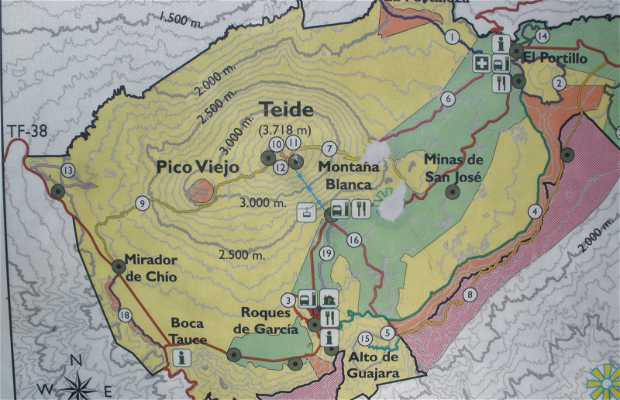
Tenerife has the privilege of having the highest peak in Spain, Mount Teide, which is also third largest volcano at 3,718 meters. Every year thousands of people come here and this has caused the creation of a cable car that almost reaches the summit, around 3,500 meters. I am not in favor of creation such things, but I guess everyone has their opinion, so I recommend reaching the summit on foot. There is only one path that can start at sea level or a little later, specifically in one of the last parking areas called White Mountain. This place is at 2,340 meters. From White Mountain the way to the top can be classified into three parts.

The first hour is very simple, the road runs along a wide path from which we can begin to see how the vegetation and landscape change as we climb up. When it reaches a place called "Teide eggs", referring to the huge volcanic stones there. Here the path becomes much narrower and steep. From this time it will rise quickly and after another hour walk, you reach the shelter. Here it's about an hour from the summit. The landscape is entirely volcanic and feels like you're on another planet. This place is really unique and amazes all visitors. The last 200 meters can be covered only if you apply prior and have a Teide National Park permit. In total the ascent and descent may take about 6 hours, depending on the climate. You need to be fit as although it is not technically complicated, we are talking about a very large altitude which you should be prepared for. Moreover, the path is quite long and very steep.
Read more
+9

+14
See original

See original

Excellent
See original

See original

See original

See original

Excellent
See original
Have you been here?
Add your opinion and photos and help other travelers discover
{"cookieList":[],"cookiesGroupFormatted":{"functionality":[],"analytics":[],"marketing":[]},"layer":"\n\n
\n
\n
\n \n\n
\n minube uses its proprietary and third-party cookies to improve user experience, collect statistics on the use of our site, and serve relevant advertising on the site. To continue browsing, you must accept the use of cookies based on your preferences.\n<\/div>\n
\n \n
\n Show details\n<\/div>\n \n\n
\n
\n
\n

Information about Route of Ascent to Mount Teide